Design options to replace Sandy Springs’ Mount Vernon Highway/Johnson Ferry Road intersection with a new street “grid” or a dual roundabout drew mixed reactions from a crowd at a March 8 community meeting. Coloring many of the opinions was widespread opposition to the grid option’s new four-lane cut-through street that would run through what is now a Sandy Springs Branch Library park.
“There’s a hundred trees. My wife went out and counted,” said Greg Thompson, who lives on Johnson Ferry near the proposed cut-through road’s southern end, about the park impact. “It’s not neighborhood-friendly.”
The grid concept could still work without the cut-through road, just less efficiently, said Steve Tiedemann, the city’s manager of projects funded by a transportation special local option tax, which includes the intersection.
“It’s not the end of the world for me if it goes away,” Tiedemann said of the cut-through street concept.
The city presented the design options in two community meetings March 8 at Congregation B’nai Torah, together drawing more than 180 people, according to city officials.
The current intersection is an unusual X-shaped configuration complicated by Boylston Drive entering from the south. Located just a block east of busy Roswell Road, the intersection is known as dangerous and gridlocked during rush hour, though traffic can be light at most other times. City officials said there were more than 150 accidents reported there in 2014 through 2016.
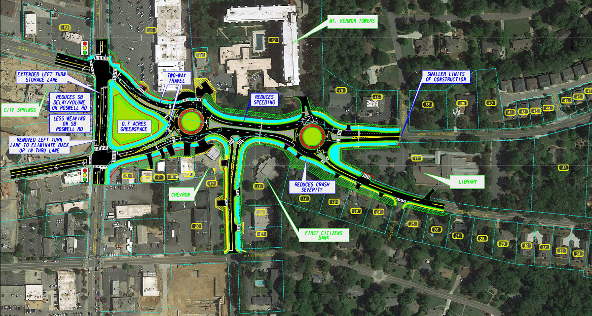
For several years, the city worked on a redesign involving dual roundabouts. Those options drew immediate criticism after their 2015 unveiling for the land-taking required and for concerns they would make traffic worse and more dangerous. Last year, Mayor Rusty Paul and the City Council called for other design alternatives. Among their considerations was how a new intersection would fit with connecting projects: possible multi-use paths and multi-modal lanes and a triangular park proposed along Roswell Road.
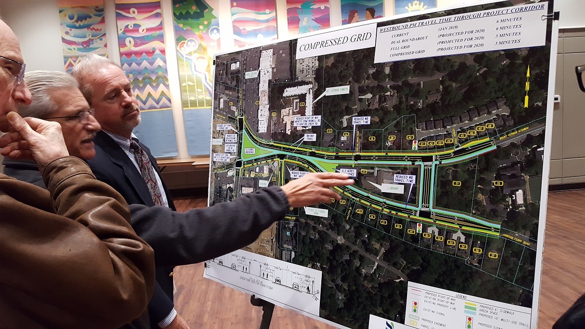
A dual roundabout is still an option, just shifted about 50 feet to the southeast. But city officials clearly favor the new grid options, saying they are less expensive and, unlike the roundabouts, would improve future rush-hour traffic flow.
In the grid concept, the intersection would be eliminated, with Mount Vernon and Johnson Ferry reconfigured as separate streets running parallel, though very close together, through that area. Boylston Drive would end there in a T intersection rather than going across both streets.
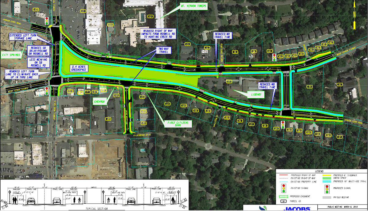
To maintain connection between Mount Vernon and Johnson Ferry for crossover traffic, a new road would be built through the park at the eastern end of the library property at 395 Mount Vernon Highway N.E. The road would have two lanes in each direction and a new traffic light at both ends. Without that road, drivers would have to use Glenridge Drive as the crossover spot instead.
The grid comes in two versions, the “full” grid and a “compressed” grid where the streets are pinched together more closely, requiring less land-taking. However, the design still requires a lot of land-taking: all commercial properties on the south side of the intersection between Roswell and Boylston would be taken, including a Chevron gas station and an Enterprise car rental outlet, officials have said.

In all three options, the streets become two-way all the way, instead of one-way at the Roswell Road intersection as they are today. And all options show a 10-foot-wide multi-use path lining the streets, with the grid options also featuring six-foot-wide sidewalks.
All three designs also preserve some amount of green space for a park at Roswell Road. In the roundabouts, the space is 0.7 acres. The full grid would create a miniature linear park of 2.4 acres. The compressed grid creates 0.8 acres at Roswell and a 0.3-acre patch adjacent to the library.
Another big change in all options is prohibiting today’s left-hand onto Mount Vernon from southbound Roswell Road, in favor of creating a longer turn lane for northbound traffic seeking to go west on Johnson Ferry.
Concerns and opinions
City engineers already say they prefer the grid options, primarily because of the projected traffic in 2020. They say that westbound evening rush-hour traffic with the roundabouts would take about 6 minutes to get through the intersection – the same as it does right now. Either grid option brings that down to 3 minutes, they say.
Tiedemann told one attendee of the evening meeting that the roundabout option “works worse than if you don’t do anything at all” in terms of traffic. “Those don’t function very well” in that intersection, he said.
Some residents expressed big-picture concerns about whether the project is necessary. They say traffic is primarily a rush-hour problem, and the project amounts to over-building to serve out-of-town commuters. But the project is on the official, voter-approved TSPLOST list, which the city by law must attempt to complete.
Residents had differing opinions as to whether the options would reduce or increase cut-through traffic in the surrounding neighborhoods. Some were concerned how it would affect the separate but connected plan to add multi-modal lanes farther east on Mount Vernon. That highly controversial concept will return in another meeting, possibly in May, and likely will involve fewer than the originally proposed four-lane road, Tiedemann said.
As for particular options, the opinions varied, but the grid’s cut-through road was a factor in forming them. Several people who preferred the roundabouts said they did so because it didn’t take the library land. And several people unhappy with the grid said they might support it without the cut-through street.
“I think it’s horrible they’re taking away that space from the library that’s so neat for kids,” said one woman at the evening meeting.
Opposition is especially strong from residents whose houses would be at either end of the new cut-through road. Kevin Henze said he and wife Brooke – who just opened the store Swell Forever on nearby Hilderbrand Drive – live in a Johnson Ferry Road house right where the cut-through intersection would be. The couple has two toddlers who they take to the library park. The couple is concerned about increased dangers from backed-up traffic and other impacts, he said, adding he thinks the grid concept has “some merit” without the cut-through.
“The personal impact on our house will be pretty severe,” Henze said. “The project encroaches more and more into protected neighborhood space.”
Next steps
The project now enters a 30-day comment period, after which city planning staff will recommend a preferred option and present it to the City Council, which will vote whether and how to proceed. When an option is chosen, Tiedemann said, design and land acquisition would take about 18 months. Then would come a lengthy and probably disruptive construction period of 15 to 18 months. Project costs are estimated at $24 million to $30 million, including land acquisition, with the roundabouts costing more and the grids less.
To view presentation materials about the options, see sandyspringsga.gov/jfmv. Comments can be sent through that website or directly to a planning staff member at rsherwood@sandyspringsga.gov.
This proposal DOES have merit minus the cut-through road. That park is enjoyed by many people and really provides a distinct neighborhood feel. To decimate property values with a 4-lane road terminating into the front lawns of homes in the area is not workable in my opinion. Proceed with the new grid design and eliminate the cut-through in my opinion. Very few cars turn right at that intersection onto Mt Vernon (intersection in front of library of JF Rd & Mt Vernon) and very few people turn left from Mt Vernon onto Johnson Ferry. The roads can run parallel with ease. No need whatsoever for a cut through road and impacting so many homes and families.
I agree! The cut through roads are unnecessary and the grids can work very well without it. Plus we can save time and money!
If a cut-through road does not exist, it will result in cars stacked all the way back past the planned cut-through road anyways, since the tiny little light at Glenridge and Johnson Ferry just east of the proposed cut-through is not meant to accommodate much traffic and Glenridge is just one lane.
Glenridge would basically serve as the cut-through if there is no cut-through next to the library, but Glenridge has only one lane on each side instead of 2 on the planned cut-through. Would be an unmitigated disaster if the grid plan went through without a cut-through.
IDEA: How about just the status quo? Believe me — that would be fine by me and is probably the best way by a mile! Not kowtowing our lives, sanity, and time in traffic to the Cobb-a-kazies is always the best idea. But, if we do end up doing a grid, there *has* to be a cut-through.
Two useful items can be agnostically added to any of the three plans (or even the status quo) should be strongly considered:
1) taking some land for a longer stacking right turn lane on Mount Vernon as it approaches Roswell. Everyone, myself included, already cuts through and will continue to cut through the Roasters Center. Give the property owner a fair price for a sliver of land allowing that and it increases safety in that shopping center to boot. Done right, this could allow probably double the number of cars through for each light cycle. Win/win.
2) Liberally use as much of the triangular “Park” as is needed for additional intelligent stacking of turn lanes on all portions of that intersection. The shortness of the green light at Roswell and inability of sufficient cars to get through the light has always been the real issue, and since tunneling under Roswell isn’t desirable or financially feasible, implementing better turn lane stacking at the cost of a slightly smaller Triangular Cancer Danger Park would also be a win/win.
PLEASE DO NOT LET YHIS PLAN GO THROUGH. I KNOW MANY PEOPLE THAT WILL LOSE THEIR YARDS AND DESTROY THEIR HOMES. PLEASE STOP THIS PLAN NOW. CATHERINE CROSSLEY
I would give my vote to the roundabouts with modification.
I feel both Grid plans and the one on the back burner (with no cut through street) do not make sense.
Why? The cut through street would eliminate the park and add two intersections. Negatively impacting neighborhood property value and safety.
With no cut through street traffic going East on JFR from Roswell to get to MVH will have to go to Glenridge.
This would create more traffic on Eastbound JFR to Glenridge and Northbound Glenridge with intersection congestion on Glenridge at JFR and MVH.
Lastly, the Grid plans create road crossover name changes that would be very confusing for a lot of drivers.