Two Sandy Springs proposals to remake Mount Vernon Highway between Roswell Road and Ga. 400 are taking shape after recent public meetings.
One project is a major reconfiguration of the road’s intersection with Johnson Ferry Road. The other project would bring a multiuse path and new sidewalks to over 1 mile of Mount Vernon.
Both projects are on the city’s special transportation tax list, which was approved by voters in 2016.
Intersection concept
The Sandy Springs City Council chose to instruct staff to begin the full design process for the “compressed” grid option for the Mount Vernon and Johnson Ferry intersection reconfiguration at its Oct. 2 meeting.
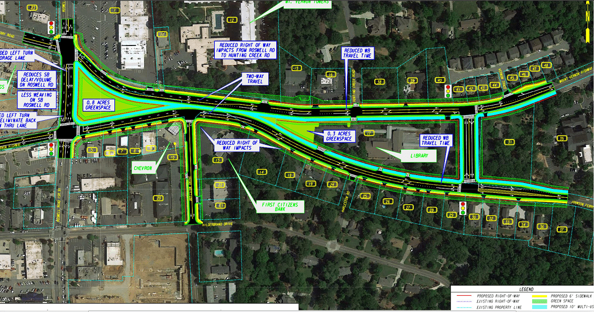
The grid concepts would change the unusual X-shaped intersection into two independent streets connected by the new, controversial cut-through road east of the Sandy Springs Library. The council previously delayed picking one of the two options, which include a full grid that would require the taking of most businesses on the south side of the intersection between Roswell and Boylston.
The compressed grid would likely save those properties, and an estimated $5 million to $10 million on right of way acquisition. The full grid would create a miniature park of 2.4 acres. The compressed grid would save 0.8 acres.
The expected cost for the compressed would be $26.6 million to $31.6 million, according to a city presentation. For the full grid, it would be $31.4 million to $36.4 million, the presentation said.
Of the comments submitted at an Aug. 30 meeting, Alan Johnson, the city’s manager of projects funded by a transportation special local option tax, said 13 people were in favor of the full grid and 10 were in favor of the compressed. Many who chose the compressed option said they did so because of cost, Johnson said.
City Councilmembers Tibby DeJulio and Jody Reichel preferred the full version. DeJulio worried the city would later regret constructing the compressed option. Reichel said many neighbors she has talked to favor the full version, and that increased green space could be used for a dog park the city has previously considered.
Councilmember Chris Burnett said he is in favor of the compressed version because it would avoid taking businesses and comes at a lower cost.
Councilmembers John Paulson, Steve Soteres and Andy Bauman made similar statements.
The council instructed staff to move forward with the compressed version and to try to save room for as much green space as possible. A full design will later come back for public input and city approval.
“This is not written in stone yet,” Bauman said.
Proposed path and sidewalks
The city proposed concepts for a multiuse path, sidewalk and center lane on Mount Vernon at an Oct. 4 public meeting about the path, where some residents voiced a desire to see the project’s orientation flipped due to property-taking concerns. The project is expected to need some residential property under the current plan.

The project is funded by the special transportation tax and is intended to provide walkability and last-mile connectivity to the Sandy Springs MARTA Station. The concept presented at the meeting would add 6-foot-wide sidewalks on the north side of Mount Vernon and 10- to 12-foot-wide sidewalks on the south side, running from Vernon Trace to just north of Abernathy Road.
Design and right of way acquisition is expected to take up the three years.
The project also feeds into the Georgia Department of Transportation’s Mount Vernon bridge project, which is widening the road from two to four lanes.
The wider path would be better on the more commercially-dominated side of the street, where the sidewalk is currently planned, rather than the residential side, some residents said at the meeting, which was held in the Studio Theatre at City Springs.
“The south side has potential to infringe more on residents’ property,” one resident said.
The city chose to put the wider path on that residential side because it would be more accessible to residents living in the single-family homes and condos along that street, Allen Johnson, the city’s TSPLOST manager, said. They are trying to minimize right of way acquisition as much as possible, he said.
But some residents said they would prefer to cross the street to access the path rather than have it eat into more of their property.
The project would also add turn lanes onto Mount Vernon from Glenridge Drive, Barfield Road, Crestline Parkway, Peachtree-Dunwoody Road and Abernathy Road, according to a meeting handout.
A center turn lane would be created down the length of the project on Mount Vernon, providing refuge for merging cars, Johnson said.
In some places, there is enough space to accommodate adding the center lane, but in other spots the road would need to be widened, Joe Gillis, a TSPLOST project manager, said. The center turn lane also adds flexibility for possible future transit projects, Gillis said.
The project is expected to be reviewed at the City Council’s work session on Oct. 16 held in City Hall, 1 Galambos Way.
For more information, visit the project’s webpage at sandyspringsga.gov/mvc.